
Excellent train access from SE London, water meadows and river views, chalk hills, a Victorian railway viaduct, Roman villa, decent pubs and a bird of prey centre are all points of interest on this walk mostly through grassland on the western side of the Darent Valley. For added Alan Partridge value there’s the opportunity to see bad golf too.
Download and print PDF of this walk here
GPX map (check your live location with arrow icon) at AllTrails here
GPX map at Ordnance Survey here (also with live location)
Distance from SE London: 40 min drive from Sydenham, 40 min from Peckham Rye station on train
Starting point: Eynsford train station, or if driving start near the Plough Inn (Google map ref 51.368101).
Steep bits? One quite long, but easy, uphill stretch (not steep). Suitable for all ages.
Buggyable? In summer, yes; in winter, less so with one bit at Lullingstone probably too muddy for many buggies (purpose-built ‘off road’ buggies will be fine though).
Good for wildlife? Yes, particularly the hillside of natural grass and native shrubs between points 8-9. Birds I’ve seen here include snipe, all woodpecker species, hobby, buzzard, kestrel, lapwing, skylark, yellowhammer, bunting etc. I’ve seen grass snakes and a weasel too at this point.
Getting there: Eynsford is on the Thameslink line from Blackfriars/Peckham Rye/Nunhead/Catford/Bromley South. Eynsford live departures/arrivals.
Dogs: You’ll need to put them on the lead at various points, such as on the road from the railway station, at the railway line pedestrian crossing after point 3, perhaps by the golf fairway between points 5 and 6, and on the road after point 10.
Pubs/tea rooms: the Malt Shovel and the Plough both in Eynsford, also the Riverside Tearoom between the two pubs. My own favourite is the Plough, but all good.
The walk in short
Point 1-2 (700m): Eynsford station is just out of the village, just off the A225. Leave the station and walk north to the village on whatever bit of pavement you can find. A few metres past the Malt Shovel pub turn left on to Riverside.
Point 2-3 (400m): Cross over the old bridge just past the Riverside Tearoom. Take care (cars). Pass the Plough Inn and keep straight on until the road bends left.
Point 3-4 (800m): Look out for signposted footpath leading uphill on the right at the aforementioned bend in the road, at a little layby. Follow path uphill, carefully cross the railway line at the pedestrian crossing (over stiles) and continue diagonally uphill towards Eagle Heights. The path passes through a hedgerow and continues diagonally to the lane leading up to Eagle Heights bird of prey centre. Cross the lane.

Looking back over Eynsford, point 3-4, walk 12
Point 4-5 (600m): Walk along the frontage of Eagle Heights, north to south. Watch out for soaring birds of prey and the huskies being exercised.
Point 5-6 (700m): Follow the path through a hedgerow and continue towards a lone tree (the same plane tree features on the Shoreham-Eynsford walk). Great views here, the highest point of the walk. Pass the tree and continue downhill. At the foot of a shallow dry valley follow the path behind a golf green and tee and walk up into the woods. It’s best to take the left fork path which soon emerges from the woods (muddy in winter) on to a grassy hillside.
Point 6-7 (300m): Head diagonally left and pass between a golf green (12th hole) and a tee (the 13th) and join a clear footpath running along the top of the hillside.
Point 7-8 (550m): Turn left on this path and pass benches with dense woods behind. The benches face a fine view of the Darent Valley (see pictures below) beyond a dry valley on the golf course. Walk downhill on the clear footpath to the right into the dry valley, skirting a golf tee. At the end of this path the slope becomes very steep, with an interesting plantation of yew, shrubs and small trees on the left.
Point 8-9 (450m): Turn left on the track at the bottom of the valley (or to extend the walk nicely, walk up the hill ahead then down – left, east – to the visitor centre and river visible on the valley floor about 600m away, as on the GPX map). You are now heading towards Lullingstone Castle. Soon the track bears right (between the green of the 7th and tee of the 8th) and goes uphill.
Point 9-10 (300m): Continue on the track downhill with a copse of trees on your right to Lullingstone Castle.
Point 10-11 (600m): Turn left on the lane (a few cars use this lane to reach the apartments at the castle) and pass the World Garden wall, heading north. Continue for half a mile until you reach Lullingstone Roman villa. Cross the bridge over the Darent river by the Roman villa car park and walk up a track past a farmhouse up to the A225. (If you wish to get back to the pubs/cafe, ignore this turning and take the grey route on the map above by continuing on the road under the viaduct back to the village – this adds about 1 mile to the route).
Point 11-1 (300m): Turn left on reaching the A225 and walk back along the grass verge, under the bridge to Eynsford station. Take care.
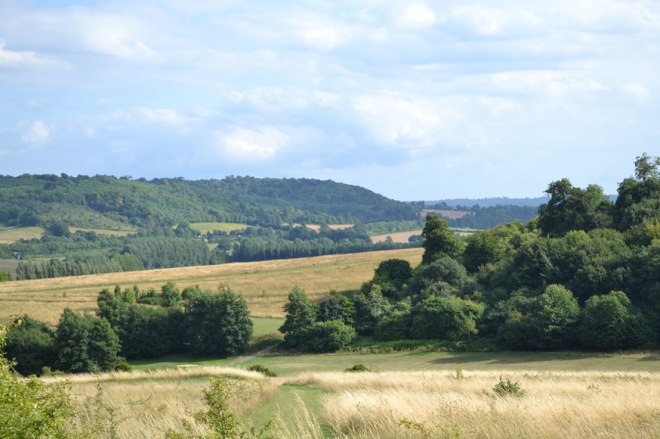
Darent Valley from Lullingstone’s high point, point 7-8: looks more like wild grassland than golf course
Detail
OK, OK, too much of this walk is on roads. I know. The station is a little too far out of town and the pavements are poor, so if you have young children with you, please take care. But these road bits are at the beginning and end, and don’t go on for too long. Eynsford has some lovely buildings, which compensates, and the river and water meadows are beautiful here. The pubs are nice and there’s plenty of history too with the remains of a Norman castle and a church (St Martins) with a Norman arch and early medieval features. Short sections of the walk you may be familiar with if you’ve done the Shoreham to Eynsford walk on this site.

Roman Villa at Eynsford
After reaching point 3 and the footpath things get very nice indeed. The hill walk is not strenuous, the view of the railway viaduct ahead of you is glorious with the valley laid out below and beyond, the sky is huge and, yep, walking in Kent doesn’t get much better. This is arable land, with winter cereals in there as I write in November. I like crossing the railway line too, which adds a bit of frisson; if you look to your right you’ll see the long tunnel that emerges at Swanley. After point 4 you reach Eagle Heights, a bird of prey centre that has really made giant strides as a visitor attraction/conservation centre in the past 20 years. Many of its birds have become stars in their right, whether it’s in the hilariously awful Made in Chelsea reality show, or in the build-up to Crystal Palace FC (the Eagles) matches at Selhurst Park, or on local news bulletins when Alaska or Chile (two bald eagles) have made off deeper into Kent and need a rescue. If you time your walk to pass by at about 3pm it’s likely you’ll see some soaring raptors or swiftly swooping falcons and hawks. Interestingly, local wild kestrels and buzzards I’ve noticed are drawn to Eagle Heights – I often see them around when passing. Anyway, it’s a good place to visit in its own right and the displays are really spectacular – it’s about £9 to get in. The walk passes the hedgerow that pens in the bird display area.
We stay high over the next few stretches; soon after point 5 we encounter the lonely damaged tree mentioned and pictured on walk 3. There’s a great, remote feeling at this point, about the highest point of the walk. You are now at the furthest point from any villages and few people are encountered on the path here. You can hear the M25 though, which is about a mile to the west, but I don’t find it intrusive. Much.
Between points 6 and 10 the walk interacts with the Lullingstone public golf course. The paths neatly pass between greens and tees and so there’s no errant ball dodging. The golf course has really long fairways and is spacious and wild; I don’t think it spoils the walk at all – in fact there are orchid-adorned Sites of Special Scientific Interest along the hillside between points 7 and 8 and really intriguing plantations of native species like blackthorn (sloe), alive with butterflies and birds in spring and summer. Close to point 8 I’ve seen grass snakes and hobbies (falcons), so it’s safe to say nature is doing OK in these parts.

Donations
If you’ve enjoyed one of the walks on this site and feel it’s enriched your day, feel free to make a small donation here if you wish. It'll encourage me to add more walks, update information and work harder to improve accuracy and quality. Thanks a lot.
£3.00
Click here for pubs and cafes on my north-west Kent walks
Lullingstone Castle was a fave of Henry VIII apparently and the church next to it (St Botolph’s) has Norman and early medieval elements. The Hart Dyke family who own the castle maintain the World Garden, containing rare specimens from all over the globe and subject to a long-running TV series. Tom Hart Dyke’s trips are not without their dangers: in Colombia he and his companions were kidnapped and kept hostage for nine months. One night he was told he would be killed the next morning and spent what he thought would be his last hours on Earth dreaming up his perfect garden. You know the rest.
Now the walk follows the lane back towards Eynsford. After about half a mile you’ll arrive at the rather tremendous remains of a Roman villa (point 11) – Lullingstone Roman Villa, with its superb mosaics and part of a 4th-century Christian chapel, one of the earliest in these heathen isles. Brilliant place, with great lighting and reminders that people were living here in a way we would recognise 2,000 years ago, which is quite humbling.
At the Roman Villa the delightful walkers on this route are faced with a grave choice: to head back to Eynsford station the long way through the village, taking in a pub (the Plough or Malt Shovel) and the Riverside Cafe mentioned above; or cross the river on the bridge, up the track past a farm house, then turn left on the A225 (careful) the short distance back to the station. If the former is your preference (nearly 1 mile extra all in), just continue on the lane (as per grey line on map above). The choice is yours.
A good blog post on this walk and the attractions along it at Lipstick n’ letters
