Drive from SE London: 40 minutes from Sydenham to Knockholt Pound.
Another North Downs escarpment walk, this time to the west of the Darent Valley, but quite near the Polhill and Andrews Woods walks. Fine views, meadows and woods feature along with a massive 18th-century mansion. A straightforward, easy-to-navigate route that surprised me with its length when I GPX’d it (it feels shorter than five miles). Chevening is an attractive hamlet with a lovely church. One strenuous uphill but nothing too severe, and a few stiles between points 3 and 5.
Shorter, 3.5 mile-version see instructions at bottom of page
Getting there: Knockholt Pound village is an easy drive on the A21. Rushmore Hill, past Coolings garden centre is the most direct route BUT that road has been shut for ages so you have do a detour either via Cudham or go up to the Badger’s Mount roundabout and take the road signposted to Halstead. There are buses, the R5 and R10, but they’re infrequent. Knockholt Station (trains from Charing Cross) is about two miles from the start of the walk so not much good really unless you can get a taxi or have a bike. It always rains when I go there – even when the forecast is good.
Download a PDF of the route to print out
For Ordnance Survey GPX map click here
Start of walk: Chevening Lane. Park in Knockholt Pound village close to the Three Horseshoes pub or at the bottom (northern end) of Chevening Lane.
Point 1-2 2km: Walk south down Chevening Lane (Point 1), a really nice road to stroll down with lovely trees and one or two vivid gardens. There are next to no cars, because it’s effectively a dead end with few houses. After about 350 metres (6 minutes?) you reach the North Downs Way footpath. Turn right here (westward). There are fields on your right – left fallow and really rewilded in summer 2022 – and dense woodland on your left. About half way to point 2 there’s a view down a cleared streak of woods of Chevening House at the foot of the scarp a couple of miles distant. The path is easy to follow as it twists around with much of the land either side private property, so there’s little risk of losing yourself. Eventually follow the path as it enters the woods and keep to the main path that forks left. This path zig zags around in slightly disorientating manner before opening out along the edge of a field and then, suddenly, you hit Point 2 – a country lane called Sundridge Hill.
Point 2-3 700m: Turn left (south) on verdant Sundridge Hill (You can take the path opposite instead and walk down the edge of a field if you like – but it only comes out via a large gate 100m further down the lane so no need.) It’s a quiet road with just the occasional car and bike so although you have to walk a third of a mile down it, it’s pretty safe. Thick hedgerows line both sides of the lane with dense woods on your left. Yellowhammers, red kites and buzzards seem common here. Walk past Knockholt Lodge on left, then around 230 metres further on you’ll come to Keepers Cottage (point 3), again on the left.
Point 3-4 1.5km: Just past Keepers Cottage, look for the footpath gate (joined to a larger gate) on the left and stride off, heading downhill through the woods heading south-east. Keep straight on at a path crossroads (the surrounding land is private so you’re on the only path you are allowed on). The path bends right down hill and soon you’ll get a lovely view over the Vale of Holmesdale and a bench to sit on. Now turn left and follow the, at first, narrow footpath easterly now and enter a meadow via woodland with a decent view of Chevening House up ahead. This meadow has a dead tree in it… maybe a lightning strike. Stay descending on this path over the odd stile and enter the Chevening Estate proper… the ‘keep out’ signs will ensure you maintain the right course! After emerging from the final bits of woodland, the path crosses a lane within the grounds amid pleasant pasture/parkland (you may encounter a herd of cows here – they’ve always been passive when I’ve been there). Note ahead, to the right, the church tower of Chevening’s St Botolph’s; that’s where we’re headed. Eventually the Chevening estate path reaches a T junction: a north-south path (point 4). (If you’ve had enough of the walk, turn left, which heads straight back to Chevening Lane – but you’ll miss some of the best bits.)
Point 4-5: 1.5km: At point 4, turn right for Chevening (south). The hamlet has the feel of somewhere that never made it out of the 1930s with its ancient telephone box, old houses and churchyard. It’s a lovely spot that always makes me want a cream tea for some reason. But that’s a Devon thing… in Kent, forget it, unless you’re in National Trust territory. Walk through the churchyard and turn left heading east and take the path directly behind. This path is pretty good for wildflowers, particularly purple thorns and knapweed, mallow and wild teasels. As a result it’s popular with birds, especially goldfinches. After about 300-500 metres, just before you reach a house and farm buildings, you’ll see a new (as of August 2025) footpath sign pointing left. Follow it! This is Point 5 (There’s no need now to walk on Sundridge Road thanks to this new path). You are also quite near the M25 here as the noise will make you aware.)
Point 5-back to start 2.8km: The longest section, and perhaps the best. From the new footpath sign (very obvious on its pole) turn north (left) on a farm track for a 100 metres or more then, when you can go no further north, turn right (east) with a hedgerow on the right. After a few metres turn left (north) on a path heading steeply uphill (do not continue straight on east). This is the strenuous bit but it’s not too long at all. Once going up the hill, follow the path as it bends slightly northwest (left), skirting Star Hill Wood. Take it slow and enjoy the views over the vale behind you and over towards Ide Hill, perched on the Greensand Ridge to the south and further east towards Kemsing Down, Ightham and Oldbury Hill. The path, actually the North Downs Way, bends round to the west – IGNORE ANY PATH OFF TO THE RIGHT. At one point it looks as if you are heading to a dead end, but it isn’t – there’s a concealed gate. Don’t take any path off to the right too early!! Our path continues on the hillside with light woods on the right until we reach the top of the scarp. Now you are heading behind the scarp face back to Knockholt. After a few metres the path turns left so continue east across a field with woods on the left. Continue through a little scrap of woodland then follow the path along the side of a field then you hit Chevening Lane again. Walk north, back down the attractive lane to the Three Horseshoes. Voila, finis.
Any pubs? Three Horseshoes by the start of the walk at Knockholt Pound. It’s got Larkins and Westerham Brewery Ales, a good beer garden and here’s the website. There’s a handy shop very close by, too, that’s usually open for drinks and snacks.
Chevening House: Still kept in government use and for the odd royal (they’re all quite odd). I think Nick Clegg lived there for a bit and Boris Johnson, Liz Truss and Dominic Raab used to argue about who was going to stay there. Sorry to mention these names – among the worst in our entire history. These days David Lammy drops by sometimes and apparently is very fond of the area – he’s been known to pop up to the Three Horseshoes. Read about it on Wikipedia or its own page here. You can’t visit it or even get very close.
What’s nearby? The huge Coolings Garden Centre, on two sites, is probably the biggest draw (road currently shut – you have to take the long way round). If you’ve time for another walk straight after this one, it’s not far to Andrews Wood (east) for the Polhill Bank/Pluto route or a quick stroll in Meenfield Woods. Or head a few miles west for the shorter Downe circular. Ide Hill isn’t far away either – from where you can look back at the Chevening route to the north.
Shorter version 3.5 miles
For your real time location see Ordnance Survey GPX map here
I was recently told this short version was one of the very best walks at KWNL. This surprised me but in mid-summer it’s an absolute treat with superb wildflowers and butterflies after point 5. Unlike the longer route the circuit starts by heading east (left on the North Downs Way).
Point 1-2 (550 metres): Park in Chevening Lane or Knockholt Pound village. Walk down to the end of Chevening Lane then take the North Downs Way path on the left, heading east. This is point 2.
Point 2-3 (400m): Walk through a field then a piece of woodland then watch out for the path on the right heading downhill through woods to the south (point 3).
Point 3-4 (1.4km): Walk downhill (possibility livestock in this field) initially through trees then emerge on open pasture with a glorious view towards Ide Hill to the south. This is a cleft in the North Downs escarpment with the path in the middle of it. Near the base of the slope it joins another path hading towards Chevening. Watch out for the church tower and head for it. The church is point 4.
Point 4-5 (800m) At the church, walk through the graveyard to the path heading east. The path passes a hedgerow and fields then look for the new footpath sign pointing north – this is point 5.
Point 5-Chevening Lane (2.5km):
After about 300-500 metres, just before you reach a house and farm buildings, you’ll see a new (as of August 2025) footpath sign pointing left. Follow it! This is Point 5 (There’s no need now to walk on Sundridge Road thanks to this new path). You are also quite near the M25 here as the noise will make you aware.)
Point 5-back to start 2.8km: The longest section, and perhaps the best. From the new footpath sign (very obvious on its pole) turn north (left) on a farm track for a 100 metres or more then, when you can go no further north, turn right (east) with a hedgerow on the right. After a few metres you will come to a path heading left (north) steeply uphill – do not continue straight on. Up you go Once going up the hill, follow the path as it bends slightly northwest (left), skirting Star Hill Wood. Take it slow and enjoy the views over the vale behind you and over towards Ide Hill, perched on the Greensand Ridge to the south and further east towards Kemsing Down, Ightham and Oldbury Hill. The path, actually the North Downs Way, bends round to the west – IGNORE ANY PATH OFF TO THE RIGHT. At one point it looks as if you are heading to a dead end, but it isn’t – there’s a concealed gate. Don’t take any path off to the right too early!! Our path continues on the hillside with light woods on the right until we enter the trees at the top of the scarp. Now you are walking on the top of the scarp and heading behind it. After a few metres the path turns left so continue east across a field with woods on the left. Continue through a little scrap of woodland then follow the path along the side of a field then you hit Chevening Lane again. Walk north, back down the attractive lane to the Three Horseshoes. Voila, finis.

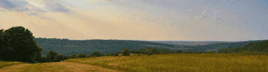
View from south of Point 3 on the short version of Knockholt Pound/Chevening walk
