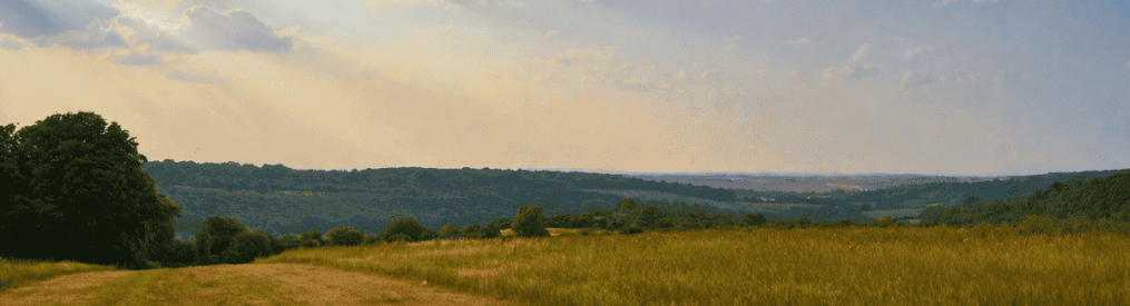
 Ancient mixed woodland, glorious views of the Kent weald over Winston Churchill’s Chartwell and an idyllic stroll alongside the River Darent just after its start are among highlights here. This is a shorter version of Walk 15 but with extra river bits. It’s most practical by car because the 246 bus terminates at Westerham, a mile away from the start. So, if you’re on the bus, try Walk 15 instead: it’s just as beautiful. It’s an easy walk – no prolonged steep slopes – but you do have to cross the River Darent by walking over a log at point 8. It’s only a little stream here but if you’re a bit unsteady on your feet please take someone relatively big and strong with you!
Access/public transport: Best by car, parking at Hosey Common; but if on public transport take bus 246 to Westerham from Bromley or Hayes station and join the walk from the alley with the stone steps towards the eastern end of the high street in Westerham, opposite the green. Use the GPX map (link below) to pinpoint your location. Other public transport options include train to Oxted then taxi (or infrequent Southdown bus 594/595).
Background: Hosey Common is now a mixed woodland but was once much more heathy with heather and gorse. It’s on sandstone, being part of the Greensand Ridge, which marks the rim of the Kent weald and is an area of woodland running almost continuously from Sussex right into east Kent, with high points including Blackdown (highest point in Sussex), Leith Hill (hightest point in SE England and, in Kent, Emmett Gardens, Toys Hill and One Tree Hill. More about the nature of Hosey Common at Kent Wildlife Trust. Tower Hill, near the end of the walk, contains an 18th century tower, a folly, which is worth a detour to look at if you can find it among giant conifers – more here. And more about historic Westerham here. This walk passes (and overlooks) Chartwell, home of Winston Churchill. The walk also skirts the beautiful Squerryes Estate, wedding venue and wine and beer producer.
Distance from SE London: 40 min drive from Sydenham
Covered on Ordnance Survey Explorer 147 map
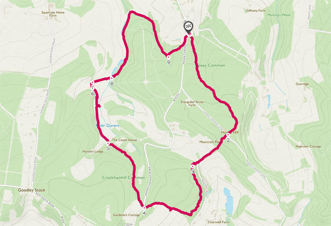
The walk (1hr 45mins/3.9 miles)
Download PDF and print out here
Follow my GPS map at Ordnancesurvey.co.uk or at alltrails.com
(Once at ordnancesurvey.co.uk, click on compass icon bottom right to find your current location, but be aware that fluctuating network strength might mean interrupted service. More techie ppl can download a GPX from the site, open the .gpx file then ‘send it’ to a GPX viewer app… prob more reliable than viewing over the internet but involves a bit of fiddling. Or download QR code from the Alltrails map.
START: Hosey Common car park (free)
Start to point 2 (1.2km) Glorious mixed woods Walk south for 30 minutes or so from the car park through mixed woodland alive with birdsong (well, sometimes) following the signs for Chartwell. The woodland is being revived by Kent Wildlife Trust so is a bit scarred where rhododendrons and other invasive species are being stripped away. Lots of tree species here, none really dominating. On the left, close to the start, is Westerham Mines… old ragstone mines that are home to many bats. Just follow the waymarkers to Chartwell… you can’t get lost.
Point 2-3 (500m) Descend to Chartwell When you hit a lane (Hosey Common Lane) you are at point 2. Just cross and take the path/bridleway opposite with a fence on your right still heading for Chartwell, now going downhill, heading roughly south west. Views start opening up to your left of the Weald and Chartwell’s lovely acres. After a few minutes you’ll see the National Trust car park on the left. The path levels and you come to Mapleton Road. Resume on the path opposite now climbing steeply uphill for a short distance, first on steps. Almost immediately look for path on the left heading south, now well elevated above the road.
Point 3-4 (1km) Mariners Hill Take the path to the left (leaving the path you are on) heading towards towering Wellingtonia conifer trees and a couple of cedars. Soon, you’ll pass gorse and find two benches; both have brilliant views over Chartwell and the Kent Weald. A really lovely spot. After 300 metres or so the path descends and meets another path. Here, turn right (west) uphill. Soon another lovely view opens up to your left across a large meadow (see yellow line on Google map above; this makes a lovely 800m extension to the walk, my mate Steve reckons it improves the walk no end – follow the footpath along the large meadow then follow the path as it turns right, west, to cross more meadows. Eventually the path leaves the meadows and turns sharp right, north, through woods high above the B2026. Soon it descends to rejoin the route at point 4, where you cross the B2026). Ignore this bit if you’ve taken the extension just mentioned: continue past the fence of a large house (Windmill Bank Cottage) with two beautiful beech trees in its garden right by the fence. Follow the path, which is slightly hidden, past the far corner of the fence – you don’t need to walk down the drive. Soon the path descends quite sharply to the B2026.
Point 4-5 (0.8km) Fused beech trees Cross the B2026 and pass the April Cottage sign on the bridlepath/path opposite. Head downhill and follow the path as it slowly bends to the north-west, passing the grounds of a house (then a couple of old chairs and a table left out for a sort of Mad Hatter’s picnic). Ignore the path off to the left you soon come across and keep on north-west through woodland, passing some truly wonderful beech trees that have all fused together… another lovely path, but very muddy after rain. If too muddy watch out for a parallel narrower path slightly above which you can take, rejoining the main path when drier a couple of hundred metres later. Soon you’ll note the grounds of a large house on your right and see open ground ahead. Pass through the metal gate into this open area: the valley of the infant Darent, a superb secluded-feeling place. You have reached point 5.


Point 5-6 (0.6km) Valley of the Infant Darent So, you’ve gone through the gate, keep going on the grassland which is the water meadow of the Darent, which is a stream off to the right. To the left is a meadow leading up to a lonely cottage. Good film location I reckon. To the right now, beyond the stream, the tall pines of Tower Hill loom. This is all a great wildlife habitat… watch out for grass snakes (you’ll never see ’em), kingfishers (not them either), buzzard (yep, seen them), bullfinch (them too), amphibians (tick – actually what out for ticks). Soon you’ll see a stile and gate up ahead.
Point 6-7 (c. a few metres) On Track Climb over the stile (or walk through the usually open gate next to it) then immediately take the track on your right leading east down to the river.
Point 7-8 (c. 100 metres) Take Me to the River Walk down the track and go straight on, on a path that leaves the track and crosses the stream, carefully using the aforementioned log – or just take a big stride. It’s not hard, but if you need a hip replacement or two, are drunk or otherwise incapacitated, seek a helping hand.
Point 8-9: (1.3km) Giant pines After crossing, turn left (north east) on the main path uphill but after about 150 metres branch left again on a path heading slightly downhill parallel with but slightly towards the stream, staying close to the river so avoiding having to climb up and over Tower Hill. What we’re doing here is skirting the hill, enjoying the stream on our left, before heading back to the car park. The Darent runs through two large shallow ponds created by dams. Brilliant for autumn colours this bit (in autumn that is). Continue on this path, ignoring another wide path branching off uphill to the right. Stay close to the river and after 800 metres or so follow the path as it leaves the river and bends sharp right (east, then south-east). You are now skirting the northern edge of Tower Hill with its giant firs and pines. On your left there is open grassland and a steep bank, which, if you were to climb you’d see a lovely view of the North Downs over Westerham. However, we’re not doing that, we’re following the contours now to the south-east and plunging back into the woods with the giant conifers uphill to the right. The path re-enters the wood turning southerly again but ignore paths off to the right and make sure you take the left turn coming up at Point 9. You’ll see signs for Chartwell again, so follow these to a path junction (point 9).
Point 9-finish (350m): The End At the junction (quite easy to miss) turn sharp left (north-east) (don’t go straight on), with an ornate garden (note the ancient-looking archway and grotto) visible through the trees to your left and soon a glimpse of a house not dissimilar to Chartwell. Shortly after that you’ll hear then hit the B2026 and will see Hosey Common car park ahead. Nifty little walk; not too difficult to navigate I hope until that bit at the end there. Good if you like trees too…
Another map view of this route (click on this screen grab for the Ordnance Survey GPS-friendly map)