


Travel time from Brockley by car: 40 mins
Start/end: Cudham recreation ground car park
Getting there: not easy by public transport I’m afraid, it means a train to Orpington then R10/R5 bus, or train to Knockholt and a taxi. For drivers the best route is the A21 to the Rose and Crown roundabout at Green St Green then drive two miles up Cudham Lane North and South to the recreation ground.
Day trip suggestion: combine with visit to nearby Down House, home of Charles Darwin, or take in another local walk: the Downe circular, Chevening or Polhill and Pluto walk. Or pop in at High Elms country park a couple of miles away on the way home.
Refreshments: Blacksmiths Arms, Cudham
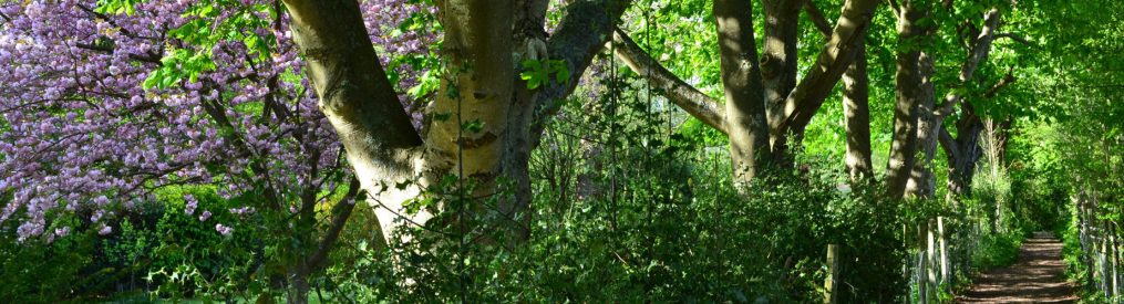
There are no far-flung vistas on this stroll, no spectacular viewpoints, no architectural wonders, no sites of special scientific interest and no historic manors. It’s just a quiet meander around an unassuming area of the rural North Downs, presenting walkers with dry valleys, bucolic glimpses, ancient and mysterious woods, little-used chalky paths and wandering lanes and aged hedgerows. It’s a real winner and deeply satisfying. There are sheep in the fields you walk through between points 5 and 6 so dogs firmly on the lead please and preferably no dogs at all in April-May when there are lambs.
Download a PDF of this walk to print out
For GPX map to follow on your phone click my routes at AllTrails or OS Maps
GPX map of shorter version of this route (3.3 miles)
The pink line on the Google map above shows a short cut if you want to reduce the walk to 3.3 miles.
Let’s get straight to it:
Point 1-2 1km: Park at Cudham recreation ground free car park off Cudham Lane South. Head north, following the perimeter of the cricket ground, passing behind the Blacksmith Arms pub then behind the church graveyard to reach a black gate in the far north-east corner. Go through the gate, cross a driveway for Rectory House and continue on the path heading north-east across fields. After about 600 metres the path enters a strip of woodland then emerges on to Mace Lane (point 2).
Point 2-3 1.3km: Follow almost-car free Mace Lane east then north-east watching out for a wide variety of small birds in the hedgerows, as well as sloe and various berries. Soon after Mace Farm buildings the lane becomes a chalk path. Continue north-east. After about 300 metres note the path on the right that cuts across the broad field. This is a short cut, if you prefer the open to the trees, and brings you out very near point 3. If you prefer the woods (as on the GPX tracks), stay on the path as it curves east then south-east still in trees. Note (but don’t take) a broad path off to the left. This is point 3.
Point 3-4 1.1km: Ignore the path off to the left and continue south-east as the path descends into a dry valley between meadows. After reaching the foot of the shallow valley the route ascends through woodland relatively steeply before meeting another path at a T-junction. Turn left here (east) passing a sign for Norstead Manor Farm (if you wanted/needed a short cut you could turn right here and heading south on this other path, rejoining this route at point 6 – the AllTrails GPX clearly shows you how). After heading east for 500 metres or so you reach New Years Lane (point 4).
Point 4-5 1.1km: Turn left (east) on New Years Lane, now called Washneys Rd, for about 200 metres until you see a signed footpath to the right heading south. Join this path which passes over a stile then through pasture with an electric fence on the left. Just after the electric fence ends continue on the path as it enters Hayman’s Wood, a working wood with some tree-felling and muddy tracks. This bit doesn’t last long and after crossing two stiles with a forest track between them you soon emerge in a lovely field with a distant view of the Knockholt Pound mobile phone masts (that’s not why it’s lovely though!). Continue in this field (often lots of sheep) due south for several hundred metres, then just before the path descends more steeply see a stile on your right into another field (this is point 5).
Point 5-6 650m: Climb over this quite high stile into the field, in effect turning sharp right (slightly north of west) and walk across the pasture. There is no easily discernible path here so aim for corner of woods on the far side – the metal walkers’ gate we are aiming for is initially hidden, but is obvious once you’ve walked 100 metres or so, and will get you into lovely ancient woodland (called Birches Croft – really part of New Years Wood – nice names). After 500 metres you emerge on to New Years Lane once again, close to New Year Cottage. This is point 6. (If you took the short cut I mentioned earlier between 3 and 4 you will also emerge here but on the other side of the lane.)
Point 6-7 900m: I said earlier there were no architectural wonders on this route. I lied. New Year Cottage, which houses a cattery and lots of nice flowers, is a very unusual building for the area: low slung with a verandah and, for me, a hint of New Mexico about it. But that might just be me. Anyway, cross the quiet lane and take the path, a bridleway, on the left heading south-west back towards Cacket’s Farm and Cudham through more delightful woods on a nice surfaced path so not so muddy. After 350 metres or so the path descends and turns south on the edge of New Years Woods to enter another grassy dry valley (actually one we saw earlier). Follow the path until a stile on the right gives you access to the grassy valley itself with farm buildings on top of the slope. This brings you out on to Cacket’s Lane and point 7.
Point 7-8 900m: Cacket’s Lane is quiet too but because it links Cudham with Knockholt Pound it’s a wee bit busier than the other lanes encountered so take care. Turn right (west) on Cacket’s Lane and after 500 metres take the footpath on the right (north of west) which will take you back across pasture and by lovely pines and a rambling old house back to Cudham recreation ground, entering it from the east. If you’re lucky, there’ll be a Cudham Wyse village cricket match going on and a Spitfire will fly over, heading back to Biggin Hill. You’ll feel you’re in a historical theme park and should have paid £35 to enter. Instead, it’s all free.
This walk reminds us that in the past there was little difference between paths and tracks; here more than any other walk on this site, the quiet lanes are extensions of the paths, it’s just that occasionally they have a car or two on them, but not often. See my cycle routes in this area – they are utterly superb! Visit the church, St Peter & St Paul, which is mentioned in the Domesday Book – the graves and building are very atmospheric. The Blacksmith Arms is in an early 17th-century farmhouse and has an attractive beer garden.
