Enjoy superb views throughout this great walk, initially from one of Kent’s highest villages (at 216 metres it has Kent’s highest village green and church); wander in ancient woodland on sun-dappled paths; be astonished as the woods turn blue in late April/early May and return via a wonderful National Trust garden (pay for entry). Not a long walk, but one or two steepish sections. It would be difficult to get truly lost because of the views and the church steeple landmark. Extend the walk by several miles by turning left at point 2 and heading off on the National Trust red route towards Toy’s Hill and Chartwell. For a full day out, the walk can be combined with a visit to Winston Churchill’s house, Chartwell. During Covid-19 period Emmetts Garden is closed but the footpath still goes through it, so detour uphill to the west then double back to enter garden from west, by cafe (detour is shown on the GPX map).
Access: Car or taxi from Sevenoaks is best, though there is an infrequent bus service from Sevenoaks railway station to Ide Hill – the 404, operated by Go. Click here for timetable. The bus ride only takes 20 minutes, so a taxi from Sevenoaks shouldn’t cost too much, should it?
Distance from SE London: 45 min drive from Sydenham
Covered on Ordnance Survey Explorer 147 map
The walk (1.5hrs/3 miles)
Download this walk here as a PDF and print out
Check out the route on the OS map app and check your progress in real time on the GPX map
Points 0-1: 650m. Join NT footpath marked ‘Ide Hill’ to right of church and walk downhill (doesn’t matter which path you take at a fork junction), past shetland pony pasture on right. At right-angle junction of paths, turn right and follow path first past a spring in the woods then alongside a field (on left) with barbed wire fence uphill to point 1
Point 1-2: 650m. Turn left at path junction, heading into valley past gorse bushes. Cross a little stream by a bridge and climb up other side of valley to Scords Wood and point 2
Point 2-3: 650m. Enter woods past NT sign for Toys Hill and follow path uphill for 50m for so then, at a junction, take the path on the right (the Toys Hill red route). Follow this path down steps and various twists and turns. Keep right at the next junction of paths and walk past a large pond (point 3).
Point 3-4 600m. Continue the path uphill behind the pond, ignoring any path off to the left, to the entrance of Emmetts gardens. (If garden gate closed – as during Covid-19 crisis –there’s a slightly longer detour: continue on path towards Toys Hill (west), ascending then turn right (north) and right again as shown here). Great views to south east. Enter gardens and follow signs for tea room. Once you hit the main path within the garden (just before tea room), turn right until you see an ornamental pond and rose garden on your right. Walk into this garden and right past pond
Point 4-5: 470m. Just past pond, leave Emmetts by a little gate and walk into large meadow, great views to north east. Join the footpath/lane heading downhill on your right by either going through the white gate on your right or walking diagonally across the meadow to the wooden gate in the right hand corner, which you’ll probably have to climb over. Go down lane, past tiny cricket pitch and meet Sundridge Rd.
Point 5-6: 470m. Turn right up Sundridge Rd (TAKE CARE, cars are frequent and road is narrow) for 100m, then turn left down much quieter Norman St. After 320m take a rather hidden footpath on right through gap in hedge – be alert for this path, it’s easy to miss, but the clue to its location is that it’s under a junction of telephone wires… so look out for the poles and wires.
Point 6-7: 600m. Follow path diagonally through large field, then into a second field. Exit this field by turning left next to solitary tree to stile into a playing field. Walk through playing field past playground and to left of large hut to re-enter Ide Hill from behind the Cock Inn.
The walk is great in reverse order too – do it the right way round first then next time start in the little car park behind the Cock Inn
More detail
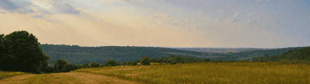
Make for the early 19th-century church (Kent’s highest church apparently) and follow the path heading south just to the right of it through light woodland (point 0). The fabulous view of the weald and Ashdown Forest is very evocative, very ‘garden of England’. To your right is a valley which you’ll shortly cross to enter the woodlands opposite (west).
Pass the church to the Octavia Hill seat After 100 metres, after passing a paddock on your right with Shetland ponies in it, the path splits; it doesn’t really matter which one you take – they end up in the same place really. The path on the left passes a seat dedicated to Octavia Hill on the left (great view from that) at an intersection with the Greensand Way. The path on the right passes more open land with gorse but meets the other path again at its foot. To continue from the OH seat, retrace your steps and take the path opposite, heading west through Ide Hill woods (if you were to take the path going past the seat heading east you’d be heading to Stubbs Wood, Goathurst Common and Sevenoaks). So you’ve retraced your steps from the OH seat and have resumed on the path heading west. It soon goes downhill and bends more towards the north. A couple of streams from spings in the hill flow over the path, so it can be very muddy in winter. Soon, the path (point 1 on the map above) leaves the woods (now heading northish) by pasture with a barbed wire fence. At the end of this field there is a junction of paths; turn sharp left (west) away from Ide Hill into a shallow valley (often with sheep in it) and towards Scord Wood, about half a mile away on the other side. To the left (south) is a wondrous view of the weald, which will accompany you for much of the walk.
An aside: Some of this route is on the Greensand Way which runs from near the Devil’s Punchbowl in deepest Surrey almost to the Kent coast and follows the layers of sandstone poking through the chalk and clays. Within the sandstone, a greenish mineral called glauconite is found, hence the trail’s name. Leith Hill, Surrey, is the highest point of the Greensand Way, at 320 metres. But don’t worry, we’re turning off well before that.
Back en route: The path is now in the rather wet little valley and after crossing a little stream on a bridge, you should soon be walking slightly uphill towards some thick woods (Scord Wood, part of the Toys Hill National Trust woodland area). In June, watch out for the foxglove ‘forest’ on your left – quite spectacular – and a superb copper beech off to the right. The path reaches the woods and runs alongside it for, say, 100 metres, then enters them by a gate (point 2) with a National Trust sign for Toys Hill. Walk another 50 metres or so through the woods then turn sharp right on a well-established path that is now gravelled, back in the direction of Ide Hill. You have now left the Greensand Way and have joined the Toys Hill ‘red route’ which follows the edge of Scord Wood, heading north, towards Emmett Gardens. It used to be incredibly muddy for much of the year but has now been gravelled. The path follows the edge of the woods and is quite up and down. Soon you go steeply down via some steps. Soon after this, ignore the path off to the left and continue right past a large artificial pond (point 3) and then over a little bridge. This pond provides the water supply for Emmetts by means of a ram pump (housed in a little hut just downhill from the pond). There’s a National Trust noticeboard which explains how the pump works – nice touch. It’s worth knowing too that this woodland and its views are partly what inspired the inspiring social reformer Octavia Hill to set up the National Trust in the 1890s, and the area also helped her form the concept of the Green Belt. Apparently, these woods are exceptional for bird watching.
The path at this point has been improved to avoid it becoming too muddy but if walking between November and April, good luck. After the pond, the path sharply shifts left and you find yourself looking down on the pond as in the picture above. You are now heading uphill, to Emmetts Garden. It’s a little steep at this point, but should be nothing for a fit, healthy humanoid like your good self. Ignore any paths off to the left, and near the top of the hill follow the path as it bends left more or less parallel with the top of the ridge. Then watch out for the Emmetts Garden sign. The view south from this point is gorgeous, stretching to the Ashdown Forest across Bough Beech reservoir and the lake at Hever Castle. It’s all made more beautiful by the wonderful trees and plants on this hillside. Awash with bluebells in spring, there are exotic trees planted here and a magnificent magnolia which blooms in late March/early April. At all times of the year it’s truly wonderful.
Enter Emmetts Gardens (remember to pay at the ticket office at the other end of the garden if lingering), admiring the wonderful azaleas, pines and various other rare shrubs from around the world, including many Japanese varieties. I’m rather taken by the weeping Californian spruce you can see soon after entering. This southern edge of the garden is a truly magnificent spot. In fact Emmetts is great, simple as that.
‘Av a cup of tea, go on
Continue straight on (west) if you want the excellent cafe. Otherwise, to continue the walk, turn right and go north through the gardens (remember to pay at the front entrance, as mentioned previously). As you draw level with Emmett’s House to your left (built in the 1860s by Frederic Lubbock, brother of Darwin’s buddy John, who lived near Downe) you will see a delightful rose garden with ornamental pond and small fountain on your right. Walk through this (point 4) and out of the garden across the field, back towards Ide Hill (the church spire acts as a good reference point at all times on this walk). Head for the bottom right hand corner of the field where a gate leads on to a lane which is actually a public footpath (you might have to climb over the gate, so it might be easier to turn sharp right on leaving the garden and head to the white gate). Continue downhill on this lane past the hilariously titchy Ide Hill Cricket Club pitch (definitely a batsman’s wicket).
Here the lane meets Sundridge Road (point 5). Turn right and carefully walk for 100 metres up the road (towards Ide Hill, now heading south) then take the first left on to a narrowish lane (Norman Street, virtually car-free) heading east. Walk for about 350 metres and then, after a dip in the lane and passing a large oak tree or two on your right, watch out for a well-hidden stone marked with a public footpath sign on your right (point 6). This is just a gap in the hedge so is easy to miss – switch your radar on. Take this path across a two grassy fields (maybe with sheep in them) then exit the second field through a stile to the left, into a playing field. Walk past a little playground to the left of a large hut and exit back into Ide Hill, rather nicely, by the newly-revamped Cock Inn (point 7). The pub used to advertise itself with a ‘Warm beer, grumpy locals, average food, proper pub’ sign. But it’s a fine old boozer with a medieval feel thanks to its massive fireplace, low beamed ceilings and rustic aura. It’s got Greene King IPA on tap and a friendly vibe. All good.

Donations
If you’ve enjoyed one of the walks on this site and feel it’s enriched your day, feel free to make a small donation here if you wish. It'll encourage me to add more walks, update information and work harder to improve accuracy and quality. Thanks a lot.
£3.00
Ide Hill community shop and cafe
Octavia Hill centenary trail (National Trust)
The Woodman (good pub for dining just out of the village)
How the village is fighting back against losing its services
Contact me


Email me on amac49@hotmail.co.uk

Pingback: Oldbury’s trees make for a cool heatwave stroll – Kent walks near London
Pingback: Best north-west Kent bluebells of 2026 – the results are in – Kent walks near London