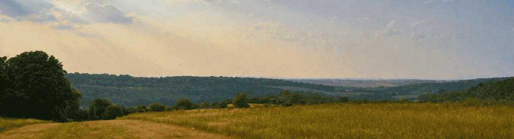
Ancient woodland clinging to the ‘cliffs’ of the Greensand Ridge, a natural ‘valley of the butterflies’, the medieval gem of Ightham Mote nestling in a gap in the hills, and a great old pub (the White Rock Inn) make this a memorable summer walk, with glorious views across the Weald to the Ashdown Forest, and rich in fauna and flora.
Access: Car needed, or taxi from Sevenoaks or Hildenborough railway stations. Refreshments at Ightham Mote NT cafe (2.5 miles), Chasers Inn (3.5 miles) and the White Rock Inn (Underriver, 5 miles)
Dogs: larger adventurous dogs should be on lead for much of this walk – see farmers’ and National Trust signs. Small well behaved pooches should be just fine.
Covered on Ordnance Survey Explorer 147 map
Distance from SE London: 50 min drive from Sydenham
The walk (3-4hrs/6 miles)
Download and print out here, or use this page on your smartphone
Click here for GPX map from AllTrails to check location in real time
The route in detail
Park your car in the small, free NT car park on Carter’s Hill (OS grid ref 147:TQ560532) then follow the broad footpath heading south (ignore the bridlepath heading left or east). The path soon begins to curve east, slightly uphill, following the line of the ridge.
After a few hundred metres you’ll reach a small grassy glade with a seat a great view over Underriver and Hildenborough. Here, you are right on top of the Greensand Ridge, a sandstone escarpment marking the edge of low weald which runs from Surrey (its highest point is Leith Hill) as far as Lympne in east Kent. Continue on the path eastward, with an orchard to your left, crossing over a stile and descending gradually in superb beech-dominated woodland. It’s all very muddy in winter this bit, but superb at other times of the year.
As the path descends, you’ll eventually come to an extraordinary tree – a beech – growing out of the side of the ridge, its roots reaching many yards along the surface before disappearing underground. Some wonderful old yew trees along this part of the walk too. Great for wildflowers in spring and summer, and toadstools and various other fungi in autumn.
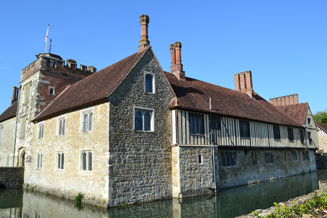
Ightham Mote
Eventually you’ll descend briefly steeply to a narrow lane (Rooks Hill) via some steps (point 3). Turn right and walk a few metres down the lane before resuming on the footpath, now narrow, on your left (point 4). The view to the south, initially across Rooks Hill Farm pasture, continues to be lovely (as pictured below).
Lush life
After a few hundred metres the vegetation becomes particularly lush and the view up to the ridge above you – with its profusion of tangled trees – spectacular. Note the sandstone boulders and many butterflies on this stretch of the walk. Butterflies and other insects do very well on this part of the route because of its south-facing, sheltered aspect. We have seen slow worms and lizards here too. The vegetation and trees are undisturbed being on a steep slope. At various points there’s almost a tropical feel as the lie of the land creates humid, windless conditions.
Mote point
Pass a sign stating that you are now in the Ightham Mote NT estate, and continue. Then descend some steps to walk past a pretty cottage. To shorten the walk to just 3.5 miles turn right here and follow the path along the field fringe down to Budd’s Green (point 14), which you can see below, continuing the walk from point 14.
If continuing on the longer 6-mile walk, pass the cottage and walk along the track/country lane (point 6) all the way to Ightham Mote (point 7). This is a truly beautiful 15th-century manor with glorious gardens. Pass Mote Farm with its oast houses (barn owls sometimes are seen here in the evening) you’ll reach Mote Road, a quiet lane. Turn right (south), and then a few metres down the lane you can cross a stile into a field on the left where the path continues. (To see Ightham Mote or visit the cafe cross Mote Rd and continue down to the path by the hedge.) Enter a rather magical small pine-dominated wood (South Seer Wood, point 8) alive with the calls of wrens, coal tits and goldcrests.
On leaving the wood (point 9) continue on the path to Shipbourne church visible ahead of you (point 10). There’s an excellent pub (the Chaser Inn) by the church if you need refreshments at this point (not visible from the path). To continue the walk, turn sharp right (point 11), now heading west away from the church on a path crossing a vast field towards some larger woods (a lot of pine again). Enter the woods (point 12) and walk 100 metres or so to a fork junction (point 13). Take the path on the left here, ignoring the ambiguously positioned footpath sign.
Soon you’ll descend through a dark coniferous ‘tree tunnel’ (very muddy in winter) and come out at Budd’s Green (point 14). Cross the road, bearing slightly left, across a patch of grass and follow the footpath down the side of the house. Ignore the barking of the dogs, if any – they are trained not to leave the garden so don’t worry. Walk past a pond (point 15) and come out in a field. Sorry to be a bit vague at this point but just continue on the path (I think in one field diagonally) in fields, copses, through hedgerows, farm buildings. All nice and obvious.
Pastures new
Walk alongside a small wood (Ducks Grove) on the right and follow the path as it turns right (point 16) and you’ll come out by some cottages. The path here joins a lane (Underriver House Road, point 17). Turn right up the lane then left over a stile into fields. Make for the large oak tree on the other side of the field (point 18) where a stile will take you into the next field – note cricket pitch away to right. There are four or five small/medium fields to cross before you reach Underriver. You are heading west and can see Underriver ahead of you now anyway – you can’t get lost.
Finally you’ll reach the lane (Carter’s Hill again) (point 20). Turn left to the White Rock Inn where there’s a great beer garden, my favourite of any on these walks in fact. In summer there are performances of Shakespeare at the Inn and a music festival. There’s also a proper boules court (pitch?).
In 1927 there was a famous plane crash in Underriver when a Fokker passenger plane flying from Croydon to Rotterdam clipped a tree up on the ridge and came down killing one of the 11 people on board.
After leaving the pub, you have three choices for getting back to the car park:
- Short but on the road (slightly dangerous in fact) to cut things short, walk back to the car park uphill on Carter’s Hill going north, uphill (15 minutes). If you do this take care of cars and bikes – go in single file, the road is narrow and cars are going downhill and might not see you easily.
- A better way back (recommended): turn right (north) up Carter’s Hill then turn left on a signed footpath/bridleway opposite Underriver House Rd to Kettleshill Farm (point 21). After 400 metres or so turn right uphill just before the farm and its beautiful old hiddem oast houses on a path (marked SR157) that becomes a sunken track. After 400 metres or so, near the top, turn sharp right at a junction of paths (point 22) to follow the top of a field with lovely views to get back on to Carter’s Hill. Turn left up the road and after 200 metres you’ll be at the car park. Or, soon after the house on Carter’s Hill you come out by, turn right on a footpath (Greensand Way) then left to get to the car park (point 23).
- The scenic route back For a longer, and lovely, final section, follow the blue line on the map which shows a 1.5-mile extension to the walk. Take the footpath almost opposite Underriver’s church (not the one you can see further down the road). Over a stile into a tiny recreation field adjacent to the village hall then follow the path into woods briefly then past fields to organic Romshed Farm, which has done a good job of helping walkers with signs (though one of the stiles is in need of repair). Follow the signs and yellow-marked posts to bypass the farm to the west then at a path T junction turn right (east) and follow the enjoyable wide path with hedgerows past a lovely pond to Kettleshill Farm and its superb oast houses. Just past them turn sharp left (north) on to the sunken path going quite steeply uphill. Near the top turn right (east) and follow the edge of a field with a lovely Weald view to the south. This path comes out on Carter’s Hill just 250 metres south of the car park Even then you don’t have to walk on the road: a few metres uphill from the house opposite you see on Carter’s Hill see turn right on a footpath heading east (Greensand Way) then turn north (left) on the path back to the car park.
Pubs and cafes on my north-west Kent walks

Donations
If you’ve enjoyed one of the walks on this site and feel it’s enriched your day, feel free to make a small donation here if you wish. It'll encourage me to add more walks, update information and work harder to improve accuracy and quality. Thanks a lot.
£3.00


Pingback: Muddy matters – Kent walks near London
Pingback: The woody wonder of ancient Oldbury: a shorter route – Kent walks near London
Pingback: Find a walk that suits you – Kent walks near London
Pingback: Rain shafts and redwings – Kent walks near London
Pingback: Where are these walks exactly? – Kent walks near London
Pingback: Summer’s lease all too short – Kent walks near London
Pingback: New(ish) walking route – Hosey Common and Chartwell circular – Kent walks near London
Pingback: Best walks for autumn colour in north-west Kent – Kent walks near London
Pingback: Bluebells 2018 – will be late this year – Kent walks near London
Pingback: In the grip of the beast: snow in north-west Kent – Kent walks near London
Pingback: Exotic trees and crazy mud – Kent walks near London
Pingback: Snow flurries, mud and cloudscapes on the Greensand Ridge – Kent walks near London
Pingback: Let it snow and let peregrines unexpectedly appear – Kent walks near London
Pingback: Find a north-west Kent walk that suits you – Kent walks near London
Pingback: Summer scenes – Kent walks near London
Pingback: Bluebells around Shoreham, Ide Hill, Downe, Kent – Kent walks near London
Pingback: Country pubs on walks around Shoreham, Downe, Sevenoaks, Ide Hill and Hever, Kent – Kent walks near London
Pingback: Cities of mauve spires – Kent walks near London
Pingback: A new walk (Hever) and last chance for bluebell walks – Kent walks near London
Pingback: An early Easter as the meadows and woods wake up – Kent walks near London
Pingback: It might as well be spring… – Kent walks near London
Pingback: Christmas holiday walks | Kent walks near London
Pingback: Eight of the best walks in north-west Kent | Kent walks near London
Pingback: Ightam Mote walk added | Kent walks near London