This is the Shoreham circular walk with a two-mile extension to Otford and back bolted on. Walkers should take the opportunity to do a little exploration at Otford, see the virtually unknown Archbishop’s Palace – the victim of Cardinal Wolsey’s rise to power under Henry VIII – and other medieval/tudor buildings. Otford also has a railway station, on the same line as Shoreham. (You might also like to try Walk 14: Shoreham’s eastern valleys, Walk 16: Shoreham Circular Mk2, and Walk 19: Fackenden Down which also start at Shoreham station).
Distance/time: 5 miles/2.5 hours
Distance from SE London: 35 min drive from Sydenham, 40 min from Peckham Rye station on train
Access: Car not needed – Southeastern/Thameslink trains stop at Shoreham. Also 403 bus from Tonbridge/Dartford stops at Shoreham
Download walk pdf to print out by clicking here
View GPX map at Ordnance Survey here
Covered on Ordnance Survey Explorer 147 map
The walk in brief
Arrive at Shoreham train station, walk down the steps just outside the main entrance of the station and walk downhill on the road for a few metres until you see Darent Valley Golf on your left.
Point 1-2 800m: take the path just west of Darent Valley Golf Club heading south which crosses a golf fairway and the edge of a small cricket pitch. Reach a lane
Point 2-3 1.5km cross lane, continue straight on to Otford village, pass through car park to the high street.
Point 3-4 300m: turn right on the high street and soon look out for path on right close to river
Point 4-5 800m: Take path now heading north back towards Shoreham with the river now across a field to your left and note path junction
Point 5-6 900m: At path junction continue straight on to lane (actually the same one you crossed earlier)
Point 6-7 300m: Turn left on lane, pass converted oast house and pond with waterfall and reach a little bridge
Point 7-8 500m: Cross this little iron bridge with wooden planking over the split Darent river then turn left, alongside the stream, follow path as it becomes a track passing lovely cottages and reach Filston Lane.
Point 8-9a 500m: Cross the road and take the track straight up the hill opposite eventually passing through a gate (or over a stile, I can’t remember!) on to open grass hillside. Climb steeply out and look for path entering woods on right about two thirds of the way up, by a bench
Point 9a-9b-9c 1.3km: Follow this path heading north for a mile, going straight on at junction of paths (at 9b, unless you want to cut the walk short). Finally you approach Shacklands Rd at point 9c
Point 9c-10 700m: Turn sharp right on path heading downhill towards village; cross ‘high street’ and reach Mill Lane (point 10).
Point 10-11 800m: Head down Mill Lane and reach footpath, cross bridge and turn right (or for an interesting variation, go straight on round the back of Mount Vineyard) to take the path by the river which comes out by the village war memorial (and artist Samuel Palmer’s Water House – might have been his dad’s actually) where children splash in the river in summer (point 11).
Point 11-12 700m: Turn left to head back to the station via pubs and lovely church
The walk in detail (lots of waffling but more info)
From Shoreham station walk towards the village down Station Road. Take care on this road (especially with children) because there is no pavement. After about 200 metres you’ll see the Darent Valley Golf Club on your left. Take the footpath next to it (point 1 on the map above) and head south. This is the Darent Valley Path. You will cross a couple of the fairways after a few metres so watch out for errant balls and golfers preparing for their oh-so-important next shot. You’ll have to wait if they are. Try not to shout ‘In the hole!’ or ‘You’re the man!’ as they hit it. That’s for Americans – we don’t do that sort of thing. A polite, subliminal cough might suffice if things have gone awry. Look out for some beautiful conifers astride the fairways.
Pretty soon the path will take you along the edge of a small cricket ground. With so much ball-frolicking going on, the chances of being hit are still very slim, but once, out of the many many times I’ve done this walk, I did indeed spot a wayward golf ball zooming toward me from a distant tee shot. Soon after congratulating myself for some rather elegant evasive action I was narrowly missed by a hoicked six from a village cricketer, this time necessitating a more panicky manoeuvre.
Fields of gold
Pass by the little cricket pavilion and you’ll come across a tiny lane (point 2). Cross the lane and continue straight on. The path becomes a track and reaches Otford after about 20 minutes. Pass through the recreation ground and car park to the high st (point 3). To see the remains of Archbishop Warham’s Otford Palace turn left and cross the road by the pond. The palace was once as big, and important as Hampton Court. Henry VIII, Catherine of Aragon and their daughter Mary stayed at the palace at various times, Henry on his way to the Field of Gold meeting in France. There are a lot of remarkable old buildings around Otford. It’s a curious place with an odd little hinterland of hollows, common land and meandering paths. It’s not laid out as prettily as Shoreham and the road is a bit on the busy side, but it’s as redolent of Tudor England as a virtually unknown village can get. It’s also got a to-scale model of the solar system, for some reason, which it’s fun to walk around (it takes over an hour to get to all the planets though).
To continue our walk, turn right on reaching Otford High St (still at point 3 here) (retracing your steps if you went to the palace) and – after admiring the Tudor Pickmoss cottages – look out for the path heading back towards Shoreham on the right, which starts by the river (point 4). You can’t miss it. Admiring the views into a large garden with topiary (yews cut in to various shapes), head north on this path, which is somehow more pleasant than its parallel counterpart on the other side of the recreation ground. The path leaves the river early on and continue straight on, ignoring the path off to the right at a junction (point 5). After a couple of fields the path enters something of a tree tunnel, past the golf course, and soon you’ll hit the lane again (point 6). Turn left, downhill, and you’ll see a converted oasthouse and the sound of gushing water will alert you to the presence of an impressive pond fed by the Darent river. This is Home Farm and Mill Cottage. A sign warns not to lean on the fence by the pond… one can only guess what happened there! On the right there is another large house, part of the same farm settlement, with a fine river frontage and lovely grounds.
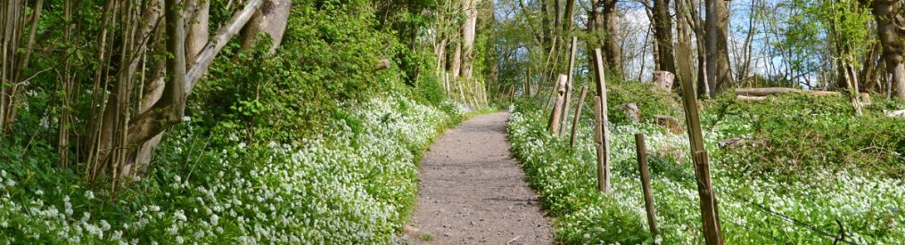
Lower Darent Valley path looking west, near Otford
Down by the riverside
Now the track becomes stony, you pass a field for horses on the right then arrive at a Darent tributary and a little iron bridge with wooden planking (point 7). It’s safe for children to wade here. After crossing take the left fork alongside the river, with a plantation of alder, beech, oak and maple trees on the right (this is Robin’s Wood, planted in memory of Robin Marshall Andrew of Kennel Cottage). During the wet winter of 2013/14 this stretch was entirely under the waters of the swollen Darent, in a flood that threatened several houses in the village (see picture in gallery below), but little damage was done.
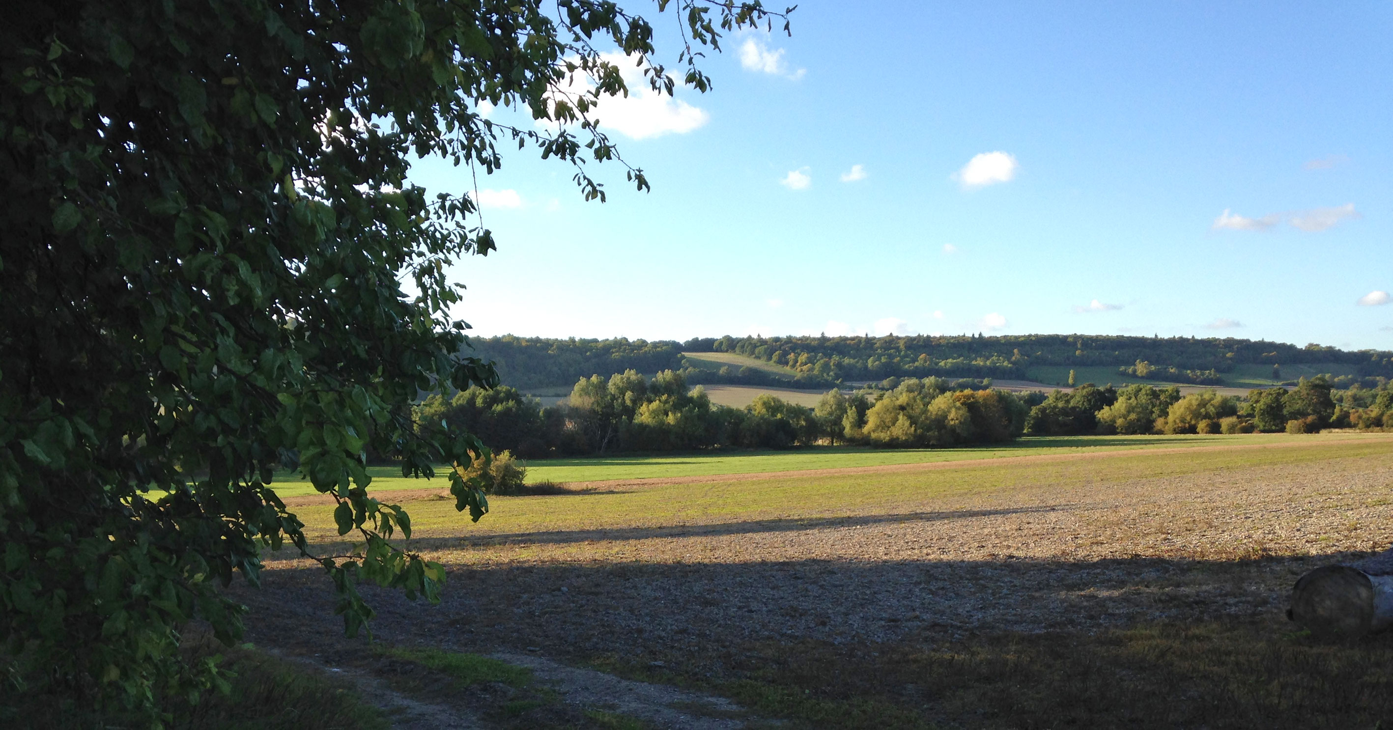
The path again becomes a little lane (Water Lane) as it begins to move slightly up hill past a couple of beautiful cottages (grade II-listed 16th-century Kennel Cottage is the first, on the right) with suitably cute gardens. Now we reach Filston Lane (point 8). Take care to cross, not that it’s busy, and head up the farm track opposite. This leads uphill towards a large grassy hillside with woods on the right. This hill is reasonably steep (great for sledging in winter) so take your time. Very occasionally the field is used by a small sheep herd, but that’s rare. You will be able to hear the M25 which cuts its way through Andrews Wood about 1km further on, but it’s not loud and won’t detract from your enjoyment of this part of the walk. The views from the hill are excellent and give you a good sense of the geography of the area – you can immediately see how the Darent has cut through the chalk. Below you is the patchwork of fields and hedges you’ve just been walking through. Opposite is the eastern valley hillside, stretching from the escarpment at Kemsing all the way north towards Dartford. It’s all a bit picture book. To the south is Otford, Sevenoaks, Knole Park and the shallow slope side of the Greensand Ridge.
Yew’ll love it
Take the footpath bearing right (point 9), just before a bench and head north, high on the valley hillside through yew, birch and beech. (Alternatively, continue to the top of the hill and turn right, point 9a, on the hilltop path through Meenfield wood, lengthening the walk by about 10 minutes.) Back on the lower path, soon the trees are only on your left, allowing for uninterrupted views over the valley. You’ll pass above the huge chalk cross cut in to the hill side to commemorate the village’s losses in the first and second world wars. If you want to shorten the walk and head back to the station (or visit the Battle of Britain museum), via the village, take the stepped footpath down on the right at a footpath crossroad (or go up the steps into Meenfield Wood to join the upper diversion route). But then you’ll be missing the next bit. Keep going on our valley-side path until it descends and meets a country lane on your left (point 9c). Here, turn right and follow the path (the one on the edge of the field, not the sunken path in the gully) back into Shoreham. After a few metres turn left off the High St on to Mill Lane (point 10) past old cottages down to the river, cross the bridge, turn right (point 11) and walk along the paved footpath by the river into the centre of the village. This is a lovely path – across the river are some back gardens of small cottages who have made some great little creative uses of their pieces of riverbank. To the left is the Mount Vineyard. (An alternative is to miss out the village and go straight on after crossing the bridge to point 11a where, having bypassed the village, you return to the walk’s starting point via the rear of the church/graveyard.)
Back on the village route you’ll reach the magnificent Water House associated with 19th century artist Samuel Palmer on the left just coming up to point 12. He created some of his finest pastoral, romantic paintings around the valley, eventually leaving Shoreham after becoming fed up with rural poverty and being visited less often by his artistic associates, the Ancients. Ahead of you is Shoreham War Memorial, which happens to be another place where children can wade in the river (point 12). The bridge here is really attractive, but there can be a lot of cars in the summer. Some beautiful words on Palmer and Shoreham here.
Walk back to the starting point past The Samuel Palmer pub and the church (ie, turn left at the war memorial).
Pubs in Shoreham: There are a lot of truly lovely cottages in this atmospheric medieval village. There are three fine pubs and a brilliant vineyard: I usually go to the The Samuel Palmer (formerly Ye Olde George) fresh from its big renovation in 2020-22. It’s now owned by the superb Mount Vineyard, 50 metres further into the village. The Crown is an excellent pub in another superb old building, as is the King’s Arms.
Otford: The Bull and Woodman are fine if unremarkable pubs, with real ales, and old buildings of real atmosphere. My favourite pub here was The Crown but that’s now closed; let’s hope the other two can stick around .

Donations
If you’ve enjoyed one of the walks on this site and feel it’s enriched your day, feel free to make a small donation here if you wish. It'll encourage me to add more walks, update information and work harder to improve accuracy and quality. Thanks a lot.
£3.00
Other reasons to visit Shoreham
There’s plenty more of interest in the village – Castle Farm and its stunning fields of lavender (superb farm shop too with renowned beef, dried flowers etc) and hops (pictured in winter), the Shoreham Aircraft Museum (so many of the villages of this area keep the memory of the Battle of Britain alive – and surviving pilots sometimes visit), and the sparkling wine producer Mount Vineyard
Naomi Watts
The great Aussie actor (Peter Jackson’s King Kong, Mulholland Drive, Flirting, The Impossible, etc) was born and spent her early years in Shoreham. Her mum was at the time an antique dealer and set/costume designer and dad was a roadie for Pink Floyd. I’ve no idea where she lived though… can’t imagine there’s a blue plaque in the offing.
Public transport
Shoreham and Otford are well connected by rail to London Victoria and London Blackfriars and are on the Sevenoaks/Thameslink line. The line passes through Elephant and Castle, Denmark Hill, Peckham Rye, Nunhead, Crofton Park, Catford, Bromley South etc. It takes about 30 minutes from Catford, 40 from Denmark Hill. Otford also connects with Kemsing, Maidstone East and Ashford International. Live departures from Shoreham and from Otford
Other walks
There are many good walks from Shoreham on marked footpaths. On this site is the one to Lullingstone (returning from Eynsford station), the Otford via Romney Street, which can be done as a circular or return from Shoreham station.
