Another great Shoreham circular walk, that can be done as an extension to most of the other Shoreham walks on this site. Allow two hours. There is one steepish 5-10 minute section as you climb back to the Pilots wood path junction above the Filston Rd field (which features so regularly in these walks!). This walk is split evenly between woodland and grass chalk downland, with a nice bit of village thrown in at the end with cafes and pubs.
Distance from SE London: 35 min drive from Sydenham, 40 min from Peckham Rye station on train
Polhill Bank, one of the main highlights of the stroll, is a site of special scientific interest managed by Kent Wildlife Trust. It consists of a steep south-facing area of grass hillside rich in flora and fauna including butterflies, orchids, reptiles and birds such as yellowhammer, kestrel, red kite, buzzard and blackcap. The KWT is currently collecting donations for more work at the SSSI.
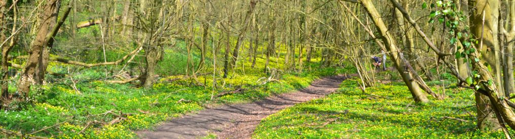
Much of the initial part of the walk is through Meenfield and Pilots woods on top of the chalk valley-crest west of Shoreham village. Meenfield woods is superb for bluebells in late April. There are great viewpoints over the Darent Valley once Polhill Bank is reached. Later, the walk descends to Shoreham village, passing the Aircraft Museum, Honey Pot cafe, then the King’s Arms pub and taking in the river walk.
Start/End: If in a car, park on the wide verge on Shacklands Rd (Google map here) just before it meets High St. Alternatively, park at Andrews Wood car park off the top end of Shacklands Rd and walk over the footbridge above the M25 and join Meenfield wood path across the valley (you can follow this GPS route) If arriving by train, walk down from the station to the village and join the walk at the war memorial (Google map here), taking the river path past the Water House.
Click here for GPX map at Ordnance Survey website
Walk instructions
CLICK HERE TO DOWNLOAD PDF FOR THIS WALK to print out
Point 1-2: SHACKLANDS RDMEENFIED WOOD 160 metres. The walk begins from the wide verge on Shacklands Road just before its junction with the High Street. Enter the woods on the signed footpath, following the path to the right (south), uphill along the line of the valley. Shortly you will reach a fork. Take the right branch, marked Meenfield Woods, and continue uphill through the woods.
Point 2-3: MEENFIELD WOODPOLHILL BANK 2.5km. The path levels out, running on top of the wooded ridge dividing the Darent Valley from the Andrews Wood Valley just to the west. It is straight on all the way for a long stretch. You will pass through a pine avenue of trees just after a path junction (go straight on), later passing a field on your left with a great view (you will see this again later). At the path junction at the top of this field continue south (straight on) entering more woods, passing the Pilots Wood sign on your right. The M25 has now become noisier. Eventually the path joins another path coming from the right and then goes past a footbridge over the motorway. After this, the path bends downhill to the left and passes through a metal gate on to Polhill Bank and a welcome bench with a great view over the head of the valley. Look for Fackenden Down opposite (my walk 19)
Point 3-4: POLHILL BANK-FILSTON FIELD 1.2km. Descend on the path above the Polhill Bank, heading east in and out of the trees, until you reach a large field. Ignore the path through the gate straight ahead, instead turn sharp left (north) in the wooded fringe. Continue past a picnic table and dense vegetation on a steep slope to the left. Soon the path climbs, curving to the left (west) as it steepens. The path finally reaches a junction you passed earlier (at the entrance to Pilots Wood). Here, turn sharp right (north-east), climbing over a stile, into a hillside field with a great view. Dogs on lead here (sheep).
Point 4-5: FILSTON FIELD-HILLSIDE PATH 800 metres. Descend the field diagonally on the path, passing a bench, then enter the woods through a metal gate. Follow the path heading north, running parallel with the Meenfield Woods path that you followed in the first part of the walk. Continue for about 700 metres until you reach a path crossroads and turn right (on a path with steps downhill to Shoreham).
Point 5-6: HILLSIDE-VILLAGE 700 metres. Descend the hillside (heading east). After 400 metres, pass Shoreham Aircraft Museum and emerge onto the High Street. Turn right, past Honey Pot cafe then take the first left into Church Street. Pass King’s Head on the right and cross road bridge over the River Darent, with a war memorial to your left.
Point 6-7-End: VILLAGE-RIVER-MILL LANE 1km. Turn left to walk past the war memorial and continue on the tarmac path along the river for about 600 metres. Cross a footbridge with Mill House beyond. Bear left to walk up Mill Lane, past ancient cottages. You will come to a T-junction with the High Street. Cross the High Street (ahead) and take the footpath which bears right along the raised verge opposite. This path leads you along the side of a field back to your car parked on Shacklands Road.

Donations
If you’ve enjoyed one of the walks on this site and feel it’s enriched your day, feel free to make a small donation here if you wish. It'll encourage me to add more walks, update information and work harder to improve accuracy and quality. Thanks a lot.
£3.00
Shoreham pubs: There are a lot of truly lovely buildings in this atmospheric medieval village. My regular pub is The Samuel Palmer (formerly Ye Olde George) which was heavily and tastefully renovated during Covid. It is owned by the superb Mount Vineyard, 50 metres further into the village. Both serve top notch food – pizzas at the vineyard, fine dining and great snacks at reasonable value at the Samuel Palmer. The Crown is an excellent pub in another superb old building, as is the King’s Arms, now reopened after a fire early in 2022.
