Secret valleys on these NW Kent walks

Secret valleys on these NW Kent walks

Kent Walks Near London can offer several lovely, lonely little valleys with their own microclimates, special flora, shelter and that precious sense of seclusion. Here are four of the best on the walks here.

1 The Darent… but not as you know it

Tower Hill, Westerham viewed from the ‘secret‘ valley of the infant Darent stream

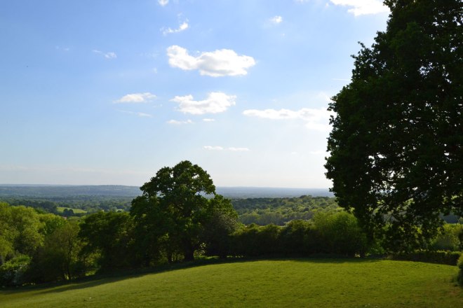
On the Hosey and Westerham walks I love the little south-north valley that winds its way from the sandstone ridge at Mariner’s Hill down to Westerham. It’s actually the valley of the River Darent just after it rises from a spring just behind the Greensand Ridge. I was delighted to realise this was where the Darent started, the stream is more associated with the chalk of the proper Darent Valley of Samuel Palmer fame – Shoreham, Otford and so on – not this obscure place near Chartwell.

Harebells
Harebells in the shadow of Tower Hill, Hosey walk

The river is bounded by beech and conifer (with Tower Hill a dark bump just to the east) and initially runs through a delightful meadow of wild grasses, unseen from the path. It suddenly broadens into large shallow pools as it heads to Westerham before turning east and making its way to its ‘proper’ valley. Autumn colours here are wonderful.

2 Magpie Bottom – great name, great valley

Magpie Bottom viewed from Austin Spring on the Fackenden walk

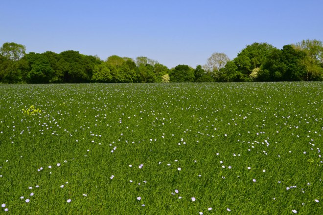
This stunning little rift in the landscape features on the Fackenden Down, Otford/Romney Street/Shoreham and the Eastern Valleys walk in different guises. It is so secluded that only walkers know of it. And the few residents of the curious hamlet I think called Upper Austin Lodge on the OS map.

Magpie Bottom is a classic steep-sided chalk dry valley (similar to but more dramatic than the ones on the Downe, Polhill and Cudham walks) running north to south from behind the escarpment. These are caused by glacial meltwater long departed. The valley’s head at Great Wood and Eastdown just behind the chalk escarpment of the North Downs to Rose Cottage farm is a series of wonderful spots unreachable by car, but really it’s gorgeous all the way down past Romney Street, Round Hill, Upper Austin Lodge and Eynsford where it meets the Darent Valley. Possibly my favourite place on all the walks, and all the better for no longer having a golf course in it!

3 A verdant vale on the way to Ightham Mote

Hidden valley behind Wilmots Hill, Ightam Mote
Broadhoath woods in the hidden valley behind Wilmots Hill, near Ightham Mote

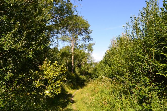
My final Kent canyon (it’s not a canyon) features on the longer version of the Oldbury/Ightham Moat route and is mentioned as a route alternative on the One Tree Hill figure of eight walk (see the blue line on the Google map at the KWNL page). So on the One Tree Hill routes it’s a diversion, a short cut that you’ll have to check your maps to include. But on the longer Oldbury walk it’s part of the deal. What shall we call it? It’s round the back of Ightham Mote and passes through a wood called Broadhoath behind Wilmot Hill (which has some of the greatest views in Kent). It has a lively little stream that rises just behind the Greensand Ridge, a terrific pond with viewing platform and interesting flora as it descends west to east to Ightham Mote itself, passing a shed built to house early 20th century hop pickers (you’d think hop pickers were in fact horses judging by the design of the housing – the landowners obviously weren’t too bothered by other people’s comfort levels). Like the other little valleys it’s good for birds: marsh tit and bullfinch have been seen here. It’s another totally secret dip, accessible only to walkers, that’s like an entry to another realm; a world away, but its paths are only 55 minutes from Sydenham.

How to use Kent Walks Near London

How to use Kent Walks Near London

It’s a great time of year for walking, as the visitor figures at Kent Walks Near London are showing. Wildflowers, birdsong, the sound of the breeze in the foliage, dry conditions and warmth are all balm for the soul – and how needed in these perplexing times.

It’s been great to bump into walkers using the website lately; generally all have been on the correct route and enjoying themselves! Only one couple were off piste, and this was because they had been following Bromley council’s signs for the Cudham circular rather than read the pdf they were holding of the Cudham Chalk Paths walk.

Ide Hill, Kent
Looking south-west across the Weald from Ide Hill

A smartphone can help

It’s been mentioned to me lately that it is still quite easy to take the wrong path at times. I really recommend using the GPX on the smartphone with takes you to my routes at Ordnance Survey or AllTrails. Here’s my Fackenden Down route at Ordnance Survey maps (actually done in reverse, but it doesn’t matter as the dot will show you where you are against the route whichever way round you’re doing the walk). If it all sounds a bit technical and you don’t want to be marching around peering at your phone, don’t worry – just take your time and read the instructions ahead so you’re not stopping every time there’s a side path and wondering if you should go down it. And if it does go wrong, enjoy that too… the countryside will still be lovely and all will come right in the end. It’s Kent, not the Amazon.

flax
Flax (linum) in a field in May, on the Fackenden Down route (walk 19), May 2025

A lot of KWNL users print off the PDF and go from there, but be warned: the PDFs are space-limited so I have to abbreviate at times. I think it’s best to use a combination of GPX map, the website on your phone and the pdf or just use a paper OS map just to check out the route in advance. Perhaps one day I’ll invent a special talking SatNav for KWNL so I can say ‘turn right, climb over the stile’ in real time. Actually, no; who wants that?

Contact me with route complications/updates

I really would appreciate people telling me when I need to update information, however. I can’t cover all the walks all the time so when things change – as they did on the Downe and Cudham walks in the past couple of years – it’d be great to get a heads up! Also, please send in bird/wildlife or plant observations… all welcome.

My best email is ammcculloch49@gmail.com for comms. I don’t bother with Facebook or Instagram much anymore (maybe I should try harder with the latter) – there’s just too much of all that and I consider social media to be run by awful people determined to do bad things generally. I deleted Twitter and I’m now on Bluesky if that’s any good to anyone (amackentwalks.bsky.social) but please excuse any tangential rantings you come across – I have other interests apart from walking (saxophone, Tottenham Hotspur etc) so it all ends up in one place.